For over 10 years SSP&A consulted to the NYSDEC spills department, evaluating and simulating the fate and remediation of fuel spills. Work focused on the sole-source aquifers of Long Island. NYSDEC used accelerated 3D site-characterization to identify the plume geometry and migration, potential receptors, and the location and characteristics of sources. SSP&A supported characterization and the design and evaluation of over 20 groundwater, soil, and vapor remedies, and presented results at public meetings and ITRC events.
Example site-specific projects include the following:
Uniondale
Leakage from underground gasoline storage tanks created a several-mile-long MTBE plume exhibiting MTBE concentrations in groundwater exceeding 1,500,000 µg/L. SSP&A was retained to model groundwater flow and the migration of MTBE. The F&T transport model was used to design a multi-well Interim Remedial Measure (IRM) to intercept and extract MTBE and other contaminants before they impacted public supply wells. SSP&A’s work was presented at public meetings in Uniondale and at a remediation charette where national experts reviewed the remediation strategy.
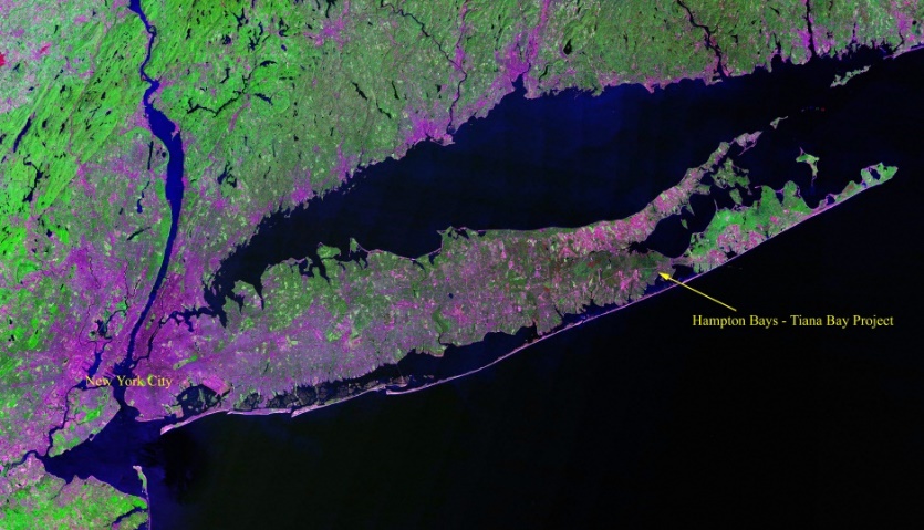
Hampton Bays
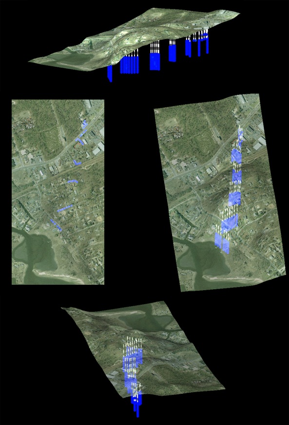
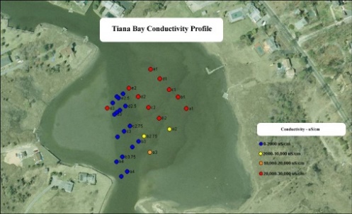
After Suffolk County Department of Health Services (SCDHS) detected 54,000 µg/L of MTBE in a Hampton Bays well, data gathered in an accelerated site assessment procedure (ASAP) guided the installation of a monitoring network to delineate contamination. The ASAP identified a mixed fuel oxygenate plume including MTBE and TBA extending 2,500 feet toward the shore. SSP&A was retained to model groundwater flow and the migration of MTBE, TBA, TAME and TAA. The F&T model was used to evaluate the potential impact on the sensitive, shallow saline water body, Tiana Bay, and to assist with the design and installation of an Interim Remedial Measure (IRM) to intercept and extract contaminants. SSP&A allocated spatially-variable recharge weighted by reported water usage data which results in the model matching the plume well indicating that enhanced recharge caused local plume diving. Data also indicated that the plume shifted in response to pumping at nearby Hampton Bays Water District (HBWD) supply wells: the model was used to simulate the impact of these wells and develop a pumping schedule for the HBWD to ensure the plume migrates toward the recovery well.
Hampton Bays was used as a demonstration site for a joint NYSDEC – ITRC – LIGRI workshop entitled “MTBE and TBA Comprehensive Site Assessment and Successful Groundwater Remediation”, at which Dr. Matthew Tonkin was an invited instructor. The prime contractor on the Hampton Bays project, Environmental Assessment & Remediations (EAR) was the recipient of the NGWA Outstanding Groundwater Remediation Project Award, and SSP&A was recognized as a co-recipient of this award.
Yaphank, Suffolk County, Long Island, NY
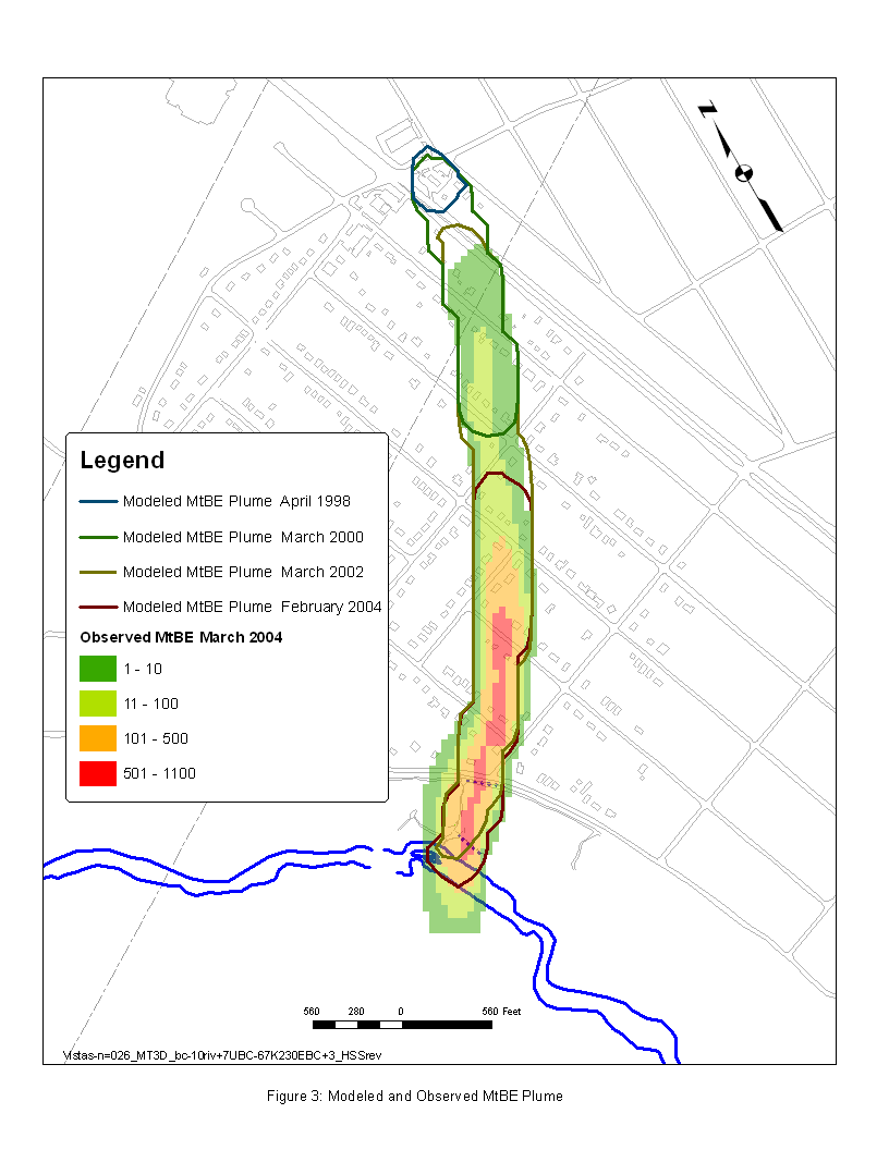
Subsurface investigation work conducted by Suffolk County Department of Health Services (SCDHS) revealed elevated MTBE and TAME in groundwater. Investigation by NYSDEC delineated an extensive fuel-spill related plume migrating toward Carman’s River. SSP&A constructed a groundwater flow and contaminant transport model to support the selection of a remedy to mitigate the discharge of the plume into the river. Pilot testing and modeling were completed to support the design of an air-sparge/SVE curtain. SSP&A converted the MODFLOW-MT3D model to MODFLOW-SURFACT (HydroGeoLogic, Inc.) enabling simulation of dissolved and gaseous contaminant phases. Actual mass recovery was evaluated against modeled recovery to assess remedy performance. Empirical data measured in multi-level monitoring points down-gradient of the AS/SVE system indicated that the remedy performed as intended, and that an additional benefit was increased dissolved oxygen in the water discharging to Carman’s River. SSP&A later supported NYSDEC and its prime contractor Environmental Assessment and Remediations (EAR) in the design, development, implementation and analysis of a multi-constituent tracer study to assist in the calibration of the model and confirm groundwater flow directions and rates in that area and confirm the source of the contaminants. The tracer study included the use of bromide, sulfur hexafluoride, and rhodamine, and predictive simulations using a curvilinear analytical transport model and the finite-difference MODFLOW/MT3D and SURFACT models.
Medford, Long Island, New York
SSP&A provided groundwater modeling support to NYSDEC, including review of an existing groundwater flow and particle tracking model, conversion of the groundwater flow model to an alternate graphical user interface (GUI) and updated version of the MODFLOW simulation code (MODFLOW-2000), together with detailed documentation of the conversion process and results. The model was deployed to simulate the likely fate of a plume of dissolved fuel constituents.
Samuel Street, Ronkonkoma, Suffolk County, Long Island, NY
In September 2001, MTBE was detected in the Suffolk County Water Authority (SCWA) Samuel Street Station Well #4. Well #4 is located in a thick sequence of the Upper Glacial Aquifer and is a significant contributor to the SCWA system. An additional SCWA well is located nearby, extracting from the same aquifer. These Samuel Street wells were previously fitted with carbon treatment due to the presence of chlorinated solvents; however, the high solubility and low sorptive properties of MTBE led to shortened life-spans for the carbon units, and increased costs. NYSDEC undertook an accelerated investigation and design of a pump-and-treat Interim Remedial Measure (IRM). Following six months of operation, data gathered from the IRM system suggested that full capture of the plume was uncertain. SSP&A was contracted to review the model, IRM operations data, and provide recommendations. Based on mass flux calculations and flow modeling, SSP&A recommended installation of a third IRM well, and modification of extraction rates at the two initial IRM wells so that the revised IRM system operates at a total extraction rate similar to the original design, which the existing treatment train (air stripping) can treat. NYSDEC adopted these recommendations, and the third IRM well was installed December 2003. Data gathered on the revised system indicated that mass removal doubled, to a rate that suggests plume capture is being maintained. Further investigations are underway regarding other possible sources of contaminants in the area, to be protective of the SCWA wells.
Rockville Center, Long Island, NY
SSP&A provided technical support to Environmental Assessment and Remediations (EAR), in support of the NYSDEC, in the development and application of a groundwater flow and contaminant transport model to (a) evaluate the likely fate of and (b) design a pump-and-treat remedy to intercept and remediate a plume of dissolved fuel constituents.
Wappingers Falls, Dutchess County, NY
On June 10th, 2004, a gasoline tanker truck overturned and released approximately 12,500 gallons of gasoline along the east edge of Jackson Road, south of the intersection with Citation Road, in Dutchess County, New York. The spill site was adjacent to Dutchess County Airport, several hundred feet east of Wappinger Creek, and several thousand feet north of the Atlas Well Field public supply wells. The spill created impacts to the surface and subsurface including the development of measurable free product upon the shallow water table, and a plume of dissolved mixed fuel constituents, including MTBE and BTEX. A drainage gully along the east side of Jackson Road carried a portion of the release northwest, while other portions flowed overland northeastward to a wooded area, and via a culvert that drained to the opposite side of Citation Road. Impact to the well field as a result of the spill was not identified. SSP&A was retained by the NYSDEC to review and consult on the data gathering efforts and interpretations completed by consultants to the responsible party, on documents pertaining to the site characterization and proposed aquifer test, and on the groundwater flow and migration of the fuel oxygenates modeling effort. SSP&A participated in several meetings with the responsible party and their consultants, and assisted in the development of a remediation and data analysis plan. Since that time, SSP&A has periodically reviewed reports prepared by the consultant to the responsible party.
Emerald New Hyde Park, Long Island, NY
SSP&A was contracted to provide technical consulting services and perform simulations of groundwater flow and the migration of fuel-related constituents to guide the design of one or more potential remedies for this large plume that extents through eastern Nassau County into the adjacent Queens County. A robust pump-and-treat (P&T) remedy evaluation methodology was developed as one approach to mitigating potential environmental impacts of this MTBE “mega-plume” comprising an estimated 5,000 kg dissolved mass or greater. Significant constraints were imposed on the remedy design due to the extent of groundwater contamination, the elevated concentration levels, and the fact that the contaminants underlie a heavily populated area. The evaluation of the alternative remedial scenarios was based on numerical modeling of groundwater flow and contaminant transport, considering alternative conceptualizations of the initial contaminant distribution; a range of pumping schemes for hypothetical recovery wells; effectiveness of hydraulic capture; and, treatment system influent rates and concentrations. The comparative remedy evaluation also considered the mass remaining in the aquifer and possible resulting impact to down-gradient receptors. Results of this evaluation are currently being used to support the development of a cost-effective remedial system that can address environmental, operational, logistical and other concerns.
Portion Road, Ronkonkoma, Suffolk County, Long Island, NY
At the Portion Road Site a plume of dissolved fuel oxygenates, of which methyl-tertiary-butyl-ether (MTBE) is the primary constituent, is migrating within the sole-source glacial aquifers down-gradient of a gasoline refueling station, toward a public supply well. Other fuel constituents released included ethanol, ethyl-tert-butyl-ether (ETBE), tert-amyl alcohol (TAA), tert-amyl-methyl-ether (TAME), and tert-butyl alcohol (TBA). Extensive investigations completed by contractors to the NYSDEC using multi-level monitoring techniques revealed a pattern of MTBE concentrations that are higher down-gradient of, than upon, the presumed source area, consistent with a substantial finite-duration release. Further investigations revealed that an accident at the refueling station released an unknown volume of fuel 3 years prior to the initial discovery of groundwater contamination. The axis of the plume is closely aligned with the supply well, and simple mass flux calculations suggest that if the supply well should intercept the majority of the plume, relevant standards for MTBE could be exceeded. In response, a single recovery well was installed to intercept the contaminants. Since commencing operations, the remedy has exhibited increasing influent concentrations of MTBE, TBA, TAME, and ETBE. The site was used by NYSDEC and SSP&A as the example application for demonstrating the linkage of the Hydrocarbon Spill Screening Model (HSSM) with MT3DMS. In 2008 SSP&A was contracted by the EPA to expand the capabilities of MT3DMS to simulate the reactive transport of fuel compounds, and the Portion Road model was used to simulate the reactive transport of MTBE, TBA, TAA, TAME, ETBE, and BTEX together with the consumption/transformation/production of the terminal electron acceptors (TEAs) oxygen, nitrate, iron, sulphate and methane. The remedy continues to operate removing MTBE, in addition to other fuel-related contaminants.
Uniondale-276, Nassau County, Long Island, NY
Multiple spill and leak events have been recorded at a gasoline station at the Uniondale-276 Site in Uniondale, Nassau County, and on-site and off-site investigations have been performed since 1998. SSP&A was retained by NYSDEC to provide technical support in order to determine the MTBE plume extents and the plume migration pathways, and to develop a monitoring well network. An existing three-dimensional groundwater flow and contaminant transport model, developed by SSP&A for the neighboring Uniondale Site, was refined and recalibrated to simulate historical hydraulic head distributions and plume migration to provide the basis for predictive simulations to assess the fate and transport of the MTBE plume. Review and analysis of the available water quality data suggested that multiple mass loading events likely occurred at the site. The model was also used for particle tracking analyses to predict plume migration pathways. These predictions were used to develop the monitoring well network for plume extent delineation. This was used together with additional mass flux and center-of-mass calculations to estimate the expected time of arrival for the plume front at selected locations, to determine the appropriate location to intercept the plume with one or more recovery wells, and appropriate locations or areas for considering monitored natural attenuation.
West Hempstead, Nassau County, Long Island, NY
SSP&A was contracted to provide technical assistance to NYSDEC and its prime contractor for the evaluation of fuel-related compounds in groundwater in West Hempstead, Nassau County, and the design of an appropriate remedy to protect several public supply wells from potential impacts. As part of an expedited process, SSP&A developed a conceptual model for the Site based on available hydrogeologic data from existing monitoring wells at and around the Site. The conceptual model formed the basis for the development of a three-dimensional groundwater flow and contaminant transport model that was calibrated to available historical water level data. Enhancements to the model included detailed mapping of low transmissivity units impacting plume migration. Alternative remedy designs were developed for the protection of the public supply wells and the selected remedy was presented at a public meeting in December 2006. As part of the remedy, the recovery wells were configured such that reversed vertical gradients would be produced to protect the deeper, more productive public supply wells while extracting contaminants in a timely manner for complete aquifer restoration. Additional particle tracking analyses were undertaken to determine migration pathways from potential source areas. The model included the operation of previously unidentified injection and extraction wells comprising an air-conditioning system at a nearby shopping center that potentially resulted in additional shallow contamination and altered plume migration patterns. The transport model was later calibrated to mass influent data from the operation of the recovery wells, and simulations were performed to obtain predictions for expected treatment system loading over time, and approximate times to achieve aquifer cleanup. The remedy ceased operations since all objectives were met.
Elmont, Nassau County, Long Island, NY
Following from a routine NYSDEC inspection at the Elmont Site, elevated concentration of MTBE, BTEX, and TBA were discovered in the soil and groundwater at and near a gasoline station. Data gathered from an Accelerated Site Assessment Procedure (ASAP) and subsequent investigations performed by NYSDEC prime contractor Environmental Assessment and Remediations (EAR) were used to develop a three-dimensional groundwater flow and contaminant transport model. SSP&A was retained to review, revise, and recalibrate the flow and transport model to help characterize the MTBE plume migration; provide recommendations for the enhancement of the monitoring well network to fully delineate the MTBE plume; and design a pump-and-treat interim remedial measure (IRM) to reduce the plume mass to ensure that contaminants do not pose a threat to public supply wells. A rapid data analysis and three-dimensional (3D) visualization methodologies were developed to support an Expedited Site Characterization (ESC) of the fugitive MTBE contamination. Rapid evaluation of the contamination by the field crew was aided by application of a robust geostatistical method (quantile kriging) of real-time field data by the modeling team. Collection of the contaminant data via direct push samples – quantified in the field using mobile laboratory facilities – proceeded rapidly over 10 days. Real-time communication of the data between the field crew and the modeling team enabled the rapid incorporation of new sampling data into the conceptual site model and geostatistical analysis of the datasets, allowing the modeling team to assess the newly obtained data and propose new sampling locations to the field crew based. This procedure, and the tools used for the design of the monitoring well network, were presented at the 2008 NGWA Conference on Eastern Regional Ground Water Issues in Ronkonkoma, New York. The remedy commenced operations in spring 2009 and is recovering MTBE, in addition to other fuel-related contaminants.
East Patchogue, Suffolk County, Long Island, NY
At this site, a plume of mixed fuel constituents migrates toward and discharges into a shallow tidal bay on the southern shores of Suffolk County. SSP&A was retained to review work completed by previous contractors and develop a sampling and monitoring program to evaluate the progress of the monitored natural attenuation (MNA) strategy adopted to address the contaminants. SSP&A collaborated with the prime contractor, Environmental Assessment and Remediations (EAR) to review all available files including maps, spreadsheets, reports, and other published material, and develop an initial three-dimensional groundwater flow and contaminant transport model to analyze the historical migration of the contaminants. The model boundary conditions incorporated the tidal effects at the tidal surface water bodies: since information on the stage levels at a pond within the model domain was limited, a sensitivity analysis was performed for various pond-stage ranges with particle tracking simulations to determine the relative discharge at the pond the Long Island Sound for each scenario.
Mineola, Nassau County, Long Island, NY
Water quality and hydrogeologic data from on-site and off-site investigations at the Mineola Site were used by SSP&A to develop a conceptual site model and evaluate the migration of a plume of MTBE and other fuel oxygenates. A public supply well is located less than a mile away from the Site, in the projected path of the plume. SSP&A constructed a three-dimensional groundwater flow and contaminant transport model to assist in the design of a pump-and-treat system protective of the public supply well. Upon commencement of the recovery well operation, groundwater investigations revealed significant variations in the local hydraulic gradient magnitude and direction as well as elevated MTBE concentrations down-gradient of the recovery well. The latter could be attributed to the varying gradient magnitude and direction, as well as limited plume characterization in the vicinity of the recovery well due to accessibility issues. In response to the posed threat to the public supply well mass-flux, and horizontal and vertical hydraulic gradient calculations, were performed to design an additional recovery well as part of an expedited procedure, to capture and extract the fugitive plume. Analyses were performed to determine the relative location of the plume center-of-mass at each monitoring transect over time to assist in the evaluation of the plume capture. The remedy commenced operations in fall 2008.
Gloria Road, South Farmingdale/Bethpage, Suffolk County, Long Island, NY
SSP&A was retained by NYSDEC to provide technical support and recommendations for the development of a monitoring network to determine the migration of a mixed MTBE and BTEX plume at the Gloria Road Site. The immediate objective of this analysis was to determine whether a proposed monitoring well would be within the plume migration pathway. Within a short time frame, SSP&A used an existing groundwater flow model and performed particle tracking analysis to evaluate numerically the plume migration pathway. The effects of recharge by a small basin near the plume boundary were also examined through sensitivity analysis to provide bounding estimates on the lateral extent of the plume pathway. Available water level data from nearby monitoring wells were gathered and tabulated and the 95th percentile of all historical data at each well were used to develop a two-dimensional hydraulic head distribution using mixed analytic-element/geostatistical methods. The mapped hydraulic head distribution was also used for a particle tracking analysis and the results were compared to the modeling results to determine the possible lateral extent of the plume migration pathway and therefore whether the proposed monitoring well would intercept the plume.

