On behalf of the Native American Rights Fund, SSP&A investigated impacts of watershed land use and conservation practices on the surface water supply for the Kickapoo Tribe of Indians in Northeast Kansas. Land use changes, including construction of ponds, sediment and flood-water control structures and application of Best Management Practices to agricultural and range land, were evaluated with respect to their impact on runoff that would otherwise be available to the Tribe in the Delaware River. SSP&A conducted hydrologic and climate analyses to characterize variations in runoff over the past several decades, GIS analyses to characterize land use changes, and crop analyses to assess changes in watershed water demand. These analyses indicated that agricultural conservation measures, while advantageous for crop production, had resulted in the retention and consumptive use of water on croplands, with a consequent reduction of runoff to surface water and reduction of water available at the Tribal point of diversion. The analyses provided motivation for negotiations over water uses within the watershed and discussions over identification and funding of alternate water supplies to ensure adequate water availabilty for the Kickapoo Tribe.
Aquifer Studies
SSP&A has completed numerous studies involving the analysis of regional aquifers and water rights over the past several years. Many of these projects involved some form of groundwater modeling, compilation and evaluation of extensive data bases, and development and presentation of expert testimony.
Kickapoo Surface-Water and Land Use Impacts
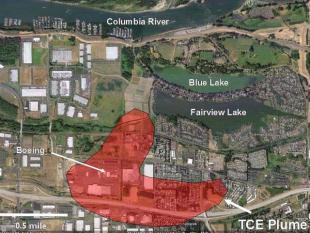
East Multnomah County Groundwater Flow Model
SSP&A developed, calibrated, and applied a regional three-dimensional groundwater flow model for a complex multi-aquifer system in the southern Portland Basin near Portland, Oregon. SSP&A used the model to aid the City of Portland in the operation of emergency public water-supply wells which were threatened with local contamination by volatile organic compounds, and to aid in the development of remedial alternatives for remediation of nearby sites. The model software and documentation were submitted by SSP&A to the City of Portland and other parties to serve as an ongoing tool for addressing groundwater contamination and water supply in the Portland area. SSP&A continues to provide expert technical advice on groundwater issues to the Oregon Department of Environmental Quality.
Kansas vs Colorado
SSP&A serves as a technical assistant to the State of Kansas in a legal dispute involving the availability of waters from the Arkansas River. The State of Kansas claimed that the State of Colorado was pumping extensive groundwater from alluvial aquifers in Colorado to an extent that it reduced stream flow in violation of the Arkansas River Compact. Other claims involved Colorado’s operation of surface reservoirs and their impact on stateline streamflows.
SSP&A has been involved in this project since 1985. Work involved analysis of streamflow data to assess depletions to streamflows in the Arkansas River, assisting in the development and application of a hydrologic-institutional model (surface-water and groundwater) to evaluate impacts of pumping and other activities on streamflows, evaluation of Colorado’s plans to replace depletions caused by pumping, and assisting in the determination of damages caused by depletions to streamflows by analyzing impacts of depletions on regional groundwater levels. Mr. Steve Larson, Executive Vice President of SSP&A, testified on behalf of the State of Kansas before a Special Master of the U.S. Supreme Court, which ruled in favor of Kansas.
C-Aquifer Model, Arizona and New Mexico
For the Salt River Project (SRP) and the Mojave Generating Station Co-Owners (Southern California Edison, SRP, Nevada Power Company, and Department of Water and Power of the City of Los Angeles), SSP&A developed a regional groundwater flow model of the C-Aquifer of Arizona and New Mexico. The groundwater flow model was designed to test the impact of a proposed well field on groundwater levels, baseflows in two habitat-critical streams (Clear Creek and Chevelon Creek) and flow at Blue Springs – a major discharge point for the C-Aquifer and a locale of cultural sensitivity to indigenous inhabitants.
The model was developed using the program MODFLOW 2000 and was based upon regional hydrogeologic, topographic, geologic, and other data from sources including published reports and databases from the U.S. Geological Survey (USGS) and Arizona Department of Water Resources (ADWR). The model was calibrated with the assistance of a non-linear parameter estimation program, PEST. Calibration targets included historical water levels, water level changes, and stream flows. The calibrated model is consistent with observed historical water level trends, baseflows in Chevelon and Clear Creeks, and transmissivity values derived from recent longterm aquifer tests in the vicinity of the proposed well field.
To evaluate the impact of the proposed well field, several scenarios were analyzed for the period 2010-2060. Two baseline scenarios for regional pumping projections were combined with three potential project pumping programs for a total of six (6) future pumping scenarios. The results indicate that under all potential project scenarios there is an adequate water supply for the proposed well field. The project pumping has a relatively small impact on wells outside of the well field, and virtually no impact on the annual discharge rate at Blue Springs. The greatest impact on baseflow in the lower, perennial reaches of both Chevelon and Clear Creeks is due to future regional pumping under either baseline scenario. The increased stream depletion due to project pumping is a small fraction of the total impact; it is also a small fraction of the total flow in these streams. An upper bound sensitivity analysis was completed for the maximum project pumping future scenario, and yielded similar results. Evaluation of water quality data from within the area of probable capture suggests that the water obtained from the potential well field will be of adequate quality for public and industrial use.
Coal Slurry Pipeline Study
A coal slurry pipeline proposed for operation in the Powder River Basin of Wyoming required pumping a large volume of water from the Madison limestone aquifer. SSP&A evaluated existing studies and developed groundwater flow and water-quality models to evaluate the impact of pumping 20,500 acre-feet per year from the aquifer. The groundwater flow model was a numerical simulation model of the aquifer which used the Monte Carlo method to assess the range of possible impacts given the statistical uncertainty in the hydraulic parameters. Water-level declines, stream-flow and spring-flow reductions, and water-quality impacts were calculated. The results of the modeling efforts were incorporated into the Environmental Impact Statement for the project.
Madison Limestone Aquifer Study
SSP&A developed mathematical models of the Madison limestone and the underlying Bighorn Dolomite in Wyoming to evaluate the potential for long-term groundwater development. SSP&A used a multi-layer, finite-difference model to simulate three-dimensional groundwater flow. The model allowed SSP&A to represent many of the specific features of the aquifers, including the boundary conditions, the unconfined conditions near rock outcrop areas, the hydraulic connection between aquifers, and the aquifer-stream interaction. Through the results of this modeling effort, SSP&A was able to determine the water-supply potential of the formations, and to outline an efficient strategy for the development of a well field that would provide the projected water supply.
Gallup Basin Study
SSP&A evaluated hydrogeologic data and reviewed existing groundwater flow models to assess the impacts of proposed groundwater withdrawals from the San Andres-Glorieta Aquifer in the Gallup Basin, New Mexico, on water levels, spring flow, and stream-base flow. SSP&A also directed additional modeling activities and provided expert testimony in water-rights litigation.
Bluewater Basin Model
A three-dimensional groundwater flow model for a regional groundwater basin in northwestern New Mexico was developed by SSP&A and was calibrated using an extensive database of historical pumping for municipal, industrial and agriculture use. The model has been used in conjunction with evaluations of surface-water conditions to assess the historical and future water levels and spring flow. The evaluations have been used to determine the impacts of water-rights transfers.
Washoe County Study and Models
SSP&A conducted a reconnaissance investigation to evaluate the availability of groundwater in northern and central Washoe County, Nevada, for export to southern Washoe County. The investigation included the preparation of an inventory of available groundwater for approximately 30 groundwater basins, the conceptual design of development schemes, the identification of hydrologic and environmental constraints on development, and the numerical evaluation of groundwater storage in selected basins as a means for terminal storage.
Las Vegas Ground-Water Basin Analysis
The Las Vegas Valley Water District, Nevada, has been developing a numerical regional groundwater flow model and approximately 25 sub-basin models to support the District's applications for water rights in these sub-basins. SSP&A is critically reviewing the development of these models and their use in the water-rights application process, and will be providing expert testimony at hearings associated with the adjudication of these water rights.