International Projects

Lefka-Xeros Mining Area, Cyprus

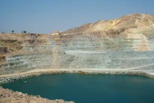
For the United Nations Development Programme, SSP&A staff completed the first comprehensive environmental assessment of Cyprus' largest copper mining and mineral processing complex. The Lefka-Xeros mining area in northern Cyprus comprises a former underground mine, open pit mine, mineral processing plant, waste rock, and ore piles, and more than 200 acres of tailings ponds, all of which were abandoned in the 1970s and 1980s. Ores from three mines were transported to the processing plant, where gold, silver, pyrite, and copper were produced by methods including flotation, cementation, and leaching for both gold (cyanide process) and copper (sulfuric acid process). Today, active agricultural and residential areas abut the former mining and mineral processing areas.  

A comprehensive site evaluation was conducted that included evaluation of all previously collected environmental data (in Greek, Turkish, and English), collection of new soil, groundwater, and mine tailings samples, evaluation of potential environmental impacts, and development of a strategic plan to evaluate and manage short-term hazards, quantify environmental impacts and develop remedial options including beneficial re-use of the mine tailings.

Successful completion of this project involved coordination with Greek Cypriot, Turkish Cypriot, and UN communities.  

Water Management Plan for Wadi Samail Aquifer

The Wadi Samail is located on the southeast Batinah coast of Oman and is underlain by an unconfined aquifer which is a major source of water supply for Muscat, the capital of Oman, and surrounding areas. Historically, the aquifer has been exploited through dug wells, and the development of several new well fields for municipal supplies have considerably increased the rate of exploitation of the aquifer. The increased pumping rates have resulted in salt-water intrusion, and consequently, in the deterioration of the water quality in many wells near the coast. SSP&A studied the hydrologic effects of alternative-development schemes for the Wadi Samail aquifer using a groundwater simulation model.

The model used to determine the behavior of the groundwater system was a vertically-averaged finite difference model that simulates the areal flow of fresh water and salt water separated by an interface. The alternatives studied included the installation of galleries at two distances from the coast, the development of spreading basins to increase aquifer recharge and groundwater production from galleries, and the elimination of garden pumpage near the coast to increase fresh-water levels and prevent salt-water intrusion.

Salalah Plain

The Salalah Plain, located in Dhofar Province in southern Oman, is underlain by an aquifer which serves as the primary source of water supply for municipal and agricultural uses in the area. In advance of projected increases in water demand, SSP&A was engaged to evaluate the potential hydrologic impacts of increased development on the Salalah Plain aquifer. SSP&A used a finite-difference model which simulated the areal flow of salt water and fresh water. Model results were used to estimate the likelihood and extent of salt-water encroachment on the fresh-water sources. Sensitivity analyses conducted during the study demonstrated the need for additional data and demonstrated the sensitivity of the model results to aquifer properties.

Saline Intrusions Studies for the Punjab and Lower Indus Plains

Under a contract with the United Nations, Department of Technical Cooperation for Development, SSP&A served as a consultant to the International Waterlogging and Salinity Research Institute (IWASRI), an agency of the government of Pakistan. The purpose of this assignment was to develop plans for field investigation and research relating to the problem of saline groundwater movement in response to irrigation pumpage in the Punjab and Lower Indus Plains.

SSP&A worked directly with Pakistan government staff and with U.N. advisers. The report prepared for this project included detailed recommendations and project plans for further work. The proposed activities included projects to develop information on saline groundwater, to develop predictive capabilities for assessing the impact of pumpage on its movement, and to test various techniques for extracting fresh groundwater located above underlying saline water. 

Groundwater Investigations, Aswan, Egypt

The aquifers in the vicinity of the High and Aswan Dams were investigated to estimate the role of reservoir filling in inducing earthquakes in the vicinity of the dams. The study involved the drilling and monitoring of a number of wells in the aquifers in the vicinity of Lake Nasseur, compilations of extensive data on the water-resources of the area, and development of a groundwater model to predict changes in pore pressure in fracture zones in basement rock beneath the reservoir. These results were used to estimate the likelihood that reservoir filling would cause earthquakes of sufficient magnitude to create dam-stability concerns. This project was funded by the USAID and was conducted in collaboration with the High and Aswan Dam Authority and Woodward-Clyde Consultants.